The new Europa Terrain Key is displayed here. The dark L’s and LL’s do not always show up well as a display PDF. The printed Key will show up clearly. We’ll be posting clips of the far north and Finland over the next few days.
We should finish re-laying out the last two maps in the next 12 days. These will be sent electronically to the printer. They will print us proof sheets for all six maps and overnight them back to us. We’ll need two days to proof the sheets and send them back. At that point, the printer will give us a slot when the maps, counters and boxes will be printed. As soon as we get the word from the printer, we’ll post the dates.
Once the printing is finished and printed, they will load the whole package on a large semi and it should take two to three days to get to Denver. We will need a day or two to unload and store it. We will then start to assemble the games and package them for shipment. We’ll try for 30-60 games out the door each day. The first to go out are the addresses we are sure of, so if you have not updated your address by e-mail, do it now and this can speed your mailing. With over 600 orders, it will take several weeks to get everything out the door.
Click on the image to see a larger view.
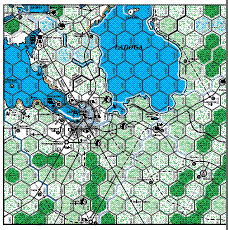

Nice looking chart. The only possible typo I see is in the wooded rough. Is the forest symbol really not overlayed on the rough? It makes it kind of hard to see if this is really the case.
Outstanding!
Of course I believe i have confirmed my address. I never heard back if it wasn’t….did it via email and phone. Phone when I ordered Storm over Scandinavia. I appreciate that you guys are really busy with getting the items out though.
Outstanding, but couldn’t print. I assume this was on purpose.
FYI- The rough woods hex is missing the top layer of woods on the chart.
Otherwise looks very impressive!
Attractive, but…. did we just take another leap in complexity above Second Front?
One of the wonderful things about Fire in the East / Scorched Earth was that I could open the box, spend some time reading the rules, and then get down to playing. Second Front was well beyond that in complexity and as a result sees decidedly less playing time.
I personally think HMS/GRD are just clogging up the maps with too many symbols.
The resource symbols, capacity airfield hexes, multitude of different border hexsides and special swamp features are really superfluous. It would be better to use actual counters to represent a country’s natural resources – that way, players can have the option of either including the higher economic/strategic conduct of WW2 in the game or just concentrating on the land/air/sea battles which is what I suspect most players (including myself) want to do.
As far as I remember, most of the articles, which appeared in TEM, looked at either historical campaign scenarios, individual unit histories or military equipment – not much was written about bauxite mines, potash or peat!
Maybe it’s just me, but I think the airfield symbols on the map should look like-well-airfields. I agree that the “A”s look too much like flak symbols, and could confuse people. If the airfield counters use the same symbol as they have in the past, then it’s a good idea to be consistent. I also think the airfield symbol would look better on the maps.